As many people head out into British Columbia’s backcountry this summer, heat and wildfires are top of mind. But as one B.C. geologist points out, there’s another hazard people might not think of.
Simon Fraser University quaternary geologist Brent Ward warns that with heat waves comes a risk of alpine landslides.
The high avalanche risk has closed Lillooet River Forest Service Road north of Pemberton. Overnight camping anywhere along the road is not recommended from July 22 until further notice.
“I worry about these landslides that we get during heat waves because of the extra melting of snow and ice in high mountains. The extra water can make the rocks weaker and we can get landslides,” says Ward.
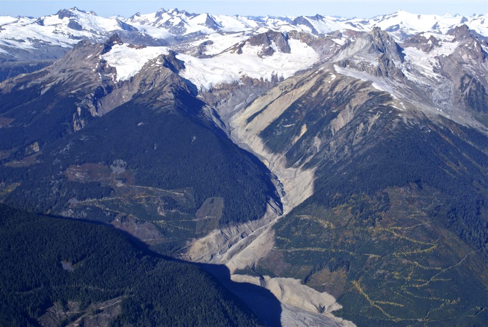
Mount Meager is a volcano and one of the "most geologically unstable areas in North America." In 2010, warm weather triggered 53 million cubic metres of rock and debris from Mount Meager, which generated the largest historic landslide in Canada. The debris travelled 12 km and blocked the Lillooet River.
“People who are doing alpine climbing and even people down the valley bottoms could be impacted,” says Ward. “Those landslides travel down the slope into the valley bottoms.”
The province put a notice out stating travel is not recommended past 20 kilometres on Lillooet River FSR 6123 (often called Upper Lillooet FSR).
A high hazard is triggered when max daily temperatures are above 25 degrees and there's a six-day average temperature of above 30 degrees with 24 hours of rainfall of more than 50 mm or 48 hours with more than 75 mm.
An extreme hazard will result in public access to the entire Upper Lillooet River Valley being restricted and gates being locked. The level of hazard is in place when daily temperatures are above 35 C and with 24-hour rainfall of more than 70 mm of rain or a 48-hour rainfall with more than 100 mm of rain.
According to the province, there is a big likelihood the landslide hazards will be high or extreme during July and August.
Ward tells Glacier Media the closure is for the public's benefit so people are not put at risk.
“The other problem with Mount Meager is it’s a heat source, so you get these hot fluids that travel through the bedrock and it weathers it and makes it a lot weaker,” says Ward.
“A lot of the rocks are unstable at the best of times, and then when you melt snow and glaciers that are on those slopes … all that material would melt as well.”
Global warming also complicates the conditions, as the permafrost starts to thaw.
“As those rocks thaw, then they're not held together as strongly and so that's been kind of indicated in some of these landslides in high areas,” he says.
Alpine landslides can be happening in other locations in B.C. as well, something Ward says is a continuing concern.
He’s advising people to respect the road closures that are in place and consider the extra hazard.


